Social Studies: The Provinces of Pakistan
Pakistan is a federation, which means that the country is made up of provinces that share power with the central government while keeping their own provincial governments, assemblies, and identities. For a Social Studies student, learning the provinces is the first step to understanding the map of Pakistan, because each province has its own capital, main languages, landscapes, crops, and cultural traditions. The four provinces are Punjab, Sindh, Khyber Pakhtunkhwa, and Balochistan, and alongside them are the federal capital territory and the northern and Azad Kashmir areas, which have their own administrative arrangements. In this guide, we look at each province in simple words, explain how the provinces work together as one country, and give students memory tricks and map habits that make this topic easy to revise and easy to answer in class.
What a Province Is and Why Pakistan Has Provinces
A province is a large administrative region of a country, with its own government that looks after matters such as education, health, agriculture, and local development within that region. Pakistan chose a federal system because the country is large and diverse, so decisions about schools, hospitals, roads, and farming are often better made close to the people they affect. At the same time, matters that concern the whole country, such as defence, foreign affairs, and currency, are handled by the federal government. This sharing of power is a balance: provinces have room to serve their own people, while the federation keeps the country united under one constitution, one flag, and one national identity that all citizens share.
For students, the simplest way to remember the idea is to think of a family with shared rules and separate rooms. The whole family follows the same house rules, just as all provinces follow the same constitution, but each room is arranged for the people who live in it, just as each province plans for its own land, climate, and people. A province also has an assembly where elected members debate laws and budgets for that province, and a chief minister who leads its government. When students understand this structure, the names of provinces stop being a list to memorise and become parts of a working system that they can explain in their own words.
Punjab: The Land of Five Rivers
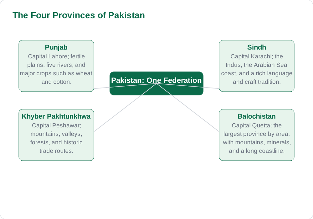
Punjab is named for its five rivers, and it is known for fertile plains, busy cities, and a strong farming tradition. Its capital is Lahore, a city famous for its history, gardens, food, and educational institutions, and other important cities include Faisalabad, Rawalpindi, and Multan. The province grows major crops such as wheat, rice, cotton, and sugarcane, and its canal system helps farmers water their fields across the plains. Punjabi is widely spoken, alongside Urdu, and the province is known for its folk music, colourful festivals, and warm hospitality. Students often remember Punjab as the agricultural heartland, but it is also a centre of industry, trade, and learning.
When studying Punjab, students should connect its geography to its economy. Flat, well-watered land makes large-scale farming possible, and farming in turn supports textile mills, food processing, and busy markets in the cities. Rivers such as the Indus tributaries have shaped settlement for centuries, because people build towns where water, transport, and trade meet. A good revision habit is to place Lahore on a blank map, then add the other major cities and the rivers that flow through the province. This map practice turns a paragraph of facts into a picture that stays in memory far longer than a list of names alone.
Sindh: The Indus, the Sea, and a Rich Culture
Sindh lies in the south-east of Pakistan, along the lower Indus River and the Arabian Sea, and its capital is Karachi, the largest city and the main port of the country. The Indus has shaped Sindh for thousands of years, watering its fields, supporting its fishing communities, and carrying trade to the sea. Sindhi is the provincial language, spoken alongside Urdu, and the province is known for its poetry, music, crafts such as ajrak and Sindhi topi, and the historic sites of Mohenjo-daro and Thatta. Agriculture, especially cotton, rice, and sugarcane, matters greatly, and Karachi adds industry, banking, shipping, and services to the provincial economy.
Students studying Sindh should notice how geography, history, and economy fit together. The river brings water for farming in the interior, the coast brings fishing and port trade, and the cities bring jobs in factories, offices, and markets. Karachi is not only a provincial capital but also a national economic hub, which is why people from all over Pakistan live and work there. For revision, students can draw the Indus flowing south into the sea, mark Karachi on the coast, and note the main crops and crafts beside each region. Students who want more study support can explore the solved notes on Solved Notes and browse the full book collection on Books.
Khyber Pakhtunkhwa: Mountains, Valleys, and History
Khyber Pakhtunkhwa lies in the north-west of Pakistan, and its capital is Peshawar, a historic city on old trade routes that once linked Central Asia with South Asia. The province is known for mountains, green valleys, and forests, and for towns such as Abbottabad, Swat, and Mardan. Pashto is widely spoken, alongside Urdu and other local languages, and the province has a strong tradition of hospitality, poetry, and crafts. Farming takes place in valleys and on terraced fields, while forests, tourism, and small industries also support livelihoods. Students often remember this province for its dramatic landscape, but its history as a meeting place of traders, travellers, and cultures is equally important.
The geography of Khyber Pakhtunkhwa explains much of its way of life. Mountain passes such as the Khyber Pass have carried trade and travellers for centuries, and river valleys have provided water and farmland in an otherwise rugged region. Tourism in scenic valleys brings visitors who enjoy the cool climate, lakes, and mountains, and this creates jobs in hotels, transport, and guiding. When revising, students should mark Peshawar on the map, trace the mountain ranges, and note how valleys and passes connect the province to its neighbours. This approach links physical geography to human activity, which is exactly what good Social Studies answers do.
Balochistan: The Largest Province by Area
Balochistan is the largest province of Pakistan by area, and its capital is Quetta, a city set among mountains in the north of the province. The landscape includes mountains, deserts, and a long coastline along the Arabian Sea, with the port city of Gwadar growing in importance for trade. Balochi and Brahui are spoken alongside Pashto and Urdu, and the province is known for its tribal traditions, handicrafts, and livestock herding. Minerals, gas, and coastal fishing are important resources, while farming depends heavily on rainfall and careful water management in a dry climate. Students should remember that large area does not mean large population everywhere, because much of the land is rugged and dry.
Studying Balochistan teaches an important lesson about resources and distance. A province can be rich in minerals and coastline yet face challenges in transport, water supply, and services, simply because towns are far apart and the terrain is difficult. Roads, ports, and water projects therefore matter greatly for development, because they connect remote communities to markets, schools, and hospitals. For classwork, students can compare Balochistan with Punjab on a simple table: area, landscape, main activities, and challenges. Such comparisons show understanding, and they help students avoid the mistake of describing every province in the same words. The class blog listing on Blog has more study guides for revision.
AI Help: Muse AI
Muse AI is Meta's personal AI assistant, and it can help you learn the provinces by quizzing you on capitals, languages, and landscapes one province at a time. For example, you can ask it to test you on a blank-map description, to explain why each province's geography shapes its economy, or to make short revision questions for a class test. Muse AI does not give official STBB answers — always verify against your STBB book and your teacher. Always verify against your Sindh Textbook Board book and your teacher before using anything in classwork.
Join Muse with invite code LTGSWD — in the Muse app, go to Settings > Redeem token and enter the code. Disclosure: LTGSWD is the author's Muse invite code.
5 key points you must know
- Pakistan is a federation of four provinces: Punjab, Sindh, Khyber Pakhtunkhwa, and Balochistan.
- Provincial capitals are Lahore, Karachi, Peshawar, and Quetta.
- Provinces handle local matters such as education and health, while the federation handles national matters.
- Geography shapes each province: rivers in Punjab, the sea in Sindh, mountains in Khyber Pakhtunkhwa, and vast dry land in Balochistan.
- Map practice, naming capitals and rivers on a blank map, is the best way to revise this topic.
Frequently asked questions
What are the four provinces of Pakistan and their capitals?
The four provinces are Punjab with Lahore as capital, Sindh with Karachi, Khyber Pakhtunkhwa with Peshawar, and Balochistan with Quetta. Alongside the provinces are the Islamabad Capital Territory and the northern and Azad Kashmir areas, which have their own administrative arrangements. Learning province and capital together, as a pair, makes revision much easier.
What is a federation in simple words?
A federation is a system in which power is shared between a central government and provincial governments. The central government handles matters for the whole country, such as defence and foreign affairs, while provinces handle matters closer to daily life, such as schools, hospitals, and local development. This sharing lets a large, diverse country stay united while serving local needs.
Why is Punjab called the land of five rivers?
Punjab takes its name from the five rivers that flow through or beside it and water its fertile plains. These rivers, together with canals, support farming across the province and explain why Punjab grows major crops and supports busy market towns. Rivers have also shaped where people settled, because water, transport, and trade naturally come together.
What makes Sindh different from the other provinces?
Sindh is shaped by the lower Indus River and the Arabian Sea, giving it both river farming and a major port city in Karachi. It has its own language, Sindhi, and a rich tradition of poetry, music, and crafts such as ajrak. Its mix of farming, fishing, industry, and port trade gives it an economy that draws on both land and sea.
How can students revise the provinces quickly before a test?
The fastest method is to practise on a blank map: mark the four provinces, write each capital, and add one river, one crop or activity, and one cultural point per province. Then cover the answers and repeat from memory, checking only the points you missed. This active recall beats reading the same paragraph many times and builds the map confidence examiners reward.
Solved notes — preview free
These guides work best with the solved exercises. Preview the solved notes free on this website — 119 solved notes for Classes 6–10 in Sindhi, Urdu, English and Arabic medium. Or browse the full solved notes catalogue for your class and medium. New solved notes are added regularly — check the catalogue for coming-soon books.