Social Studies: Map and Globe Skills
A map is a flat drawing of a place, and a globe is a round model of the Earth, and both help us find places, plan journeys, and understand the world without travelling everywhere ourselves. Students use maps every day, whether they follow a route to school, locate their town in an atlas, or trace a river from mountains to sea, and these skills grow more valuable as geography becomes more detailed. Learning map skills means learning directions, symbols, scale, and the grid of latitude and longitude, so that any map, from a classroom wall map to a page in an atlas, becomes readable and useful. In this guide, we explain each map skill in simple words, with step-by-step habits that build confidence for classwork, tests, and real-life navigation.
Maps, Globes, and Why We Need Both
A globe shows the Earth as it truly is, round, with continents and oceans in their correct relative positions and shapes, which makes it the most accurate model for understanding the whole planet. A globe is hard to carry and hard to show in detail, however, so maps are used for everyday work: a map can show one country, one city, or even one school in large detail on a flat page. The price of flatness is distortion, because a round surface cannot be flattened without stretching some areas, which is why different maps suit different purposes. Students should remember the trade-off simply: globes for true shape, maps for detail and convenience, and both for understanding the Earth.
Maps also come in many types, and students should learn to name the type before reading it. A physical map shows mountains, rivers, and plains, often with colours for height and depth, while a political map shows countries, provinces, and cities with boundaries. A thematic map shows one topic, such as rainfall, crops, or population, across an area, and a road map shows routes for travel. Asking what type of map you are looking at, and what question it answers, prevents confusion, because a student who reads a rainfall map as if it were a political map will misunderstand every colour. Good map readers always begin by identifying the map itself.
Directions and the Compass
Directions begin with the four cardinal points: north, east, south, and west, with north usually at the top of a map, and the four intermediate points, north-east, south-east, south-west, and north-west, between them. A compass rose on a map shows these directions, and a real compass uses a magnetic needle that points north to help travellers find their way outdoors. Students can remember directions with the simple sentence that never eats sour watermelon, taking the first letters for north, east, south, and west in clockwise order, and they can practise by facing north in their classroom and naming what lies to the east and west. Direction language then becomes precise: a town is not just near another town, but north-east of it, which is the language examiners expect.
Directions also help students describe journeys and locations accurately in answers. Instead of writing that a river flows vaguely downward, a good answer says it flows from north to south, and instead of saying a city is somewhere on the coast, it says the city lies on the southern coast. This precision matters in geography, because it shows that the student has actually read the map rather than guessed from general knowledge. A useful exercise is to describe the route from home to school using directions and landmarks only, without street names, and then to check the description by walking the route. Such practice turns abstract directions into a skill used with confidence.
Symbols, Keys, and Colours
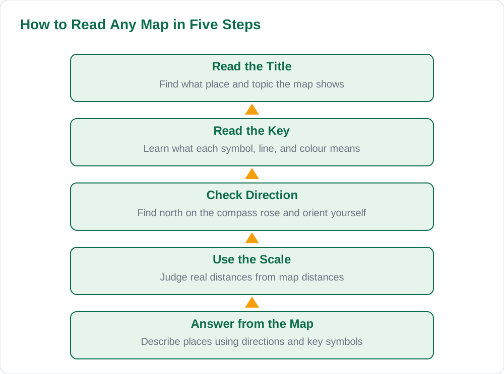
Maps use symbols because a real town, river, or mountain cannot be drawn at full size on a small page, so agreed signs stand for real features. A blue line usually stands for a river, a black line for a road or railway, a small circle or dot for a town, and a triangle for a mountain peak, but students must always check the key, also called the legend, because symbols can vary between maps. The key is the list that explains every symbol, colour, and line on that particular map, and reading it first is the most important map habit of all. A student who skips the key risks mistaking a railway for a river, or a provincial boundary for a road, and losing marks on an otherwise easy question.
Colours also carry meaning that students should learn to read. On physical maps, green often means lowland, yellow and brown mean rising land, and white or dark brown means high mountains, while blue shades show shallow and deep water. On political maps, different colours separate countries or provinces, and darker shading on a thematic map may mean higher rainfall or denser population, depending on the key. The rule is always the same: never guess a colour's meaning, always check the key, and then describe what you see using the key's own words. This habit, practised on every map, builds accuracy that examiners reward and that real navigation requires.
Scale: Measuring Real Distances
Scale tells us how map distance relates to real distance, and it is usually shown as a ratio, such as one centimetre on the map equals a stated number of kilometres on the ground, or as a bar scale drawn on the map itself. A large-scale map shows a small area in great detail, such as a town or school, while a small-scale map shows a large area, such as a whole country or the world, with less detail. Students often confuse these terms, so a memory trick helps: large scale means large detail, like zooming in, while small scale means a small, zoomed-out view of a big area. Knowing which scale a map uses prevents a student from expecting street detail on a world map or country detail on a town plan.
Using scale is a practical skill that students can practise with a ruler. Measure the map distance between two towns, multiply by the scale, and state the real distance in kilometres, showing the working so a teacher can follow it. For example, if one centimetre equals ten kilometres and two towns are four centimetres apart on the map, the real distance is forty kilometres. Practising two or three such calculations before a test removes fear of scale questions entirely, because the method never changes. Students should also remember that distances on a globe are more accurate than on a flat map, where distortion can stretch some regions, which is another reason globes remain valuable.
Latitude, Longitude, and Finding Any Place
Latitude and longitude form the grid that lets us give the exact address of any place on Earth. Latitude lines run east to west and measure distance north or south of the Equator, which is zero degrees, up to ninety degrees at the poles, while longitude lines run north to south and measure distance east or west of the Prime Meridian through Greenwich, up to one hundred and eighty degrees. Together, one latitude and one longitude pin down a single point, just as a street name and a house number pin down a home. Students should practise reading coordinates slowly: latitude first, then longitude, with north or south and east or west stated clearly, so that no place is confused with its mirror image across the Equator or the Prime Meridian.
Grid references build on this idea for detailed maps, where numbered grid lines divide a map into squares and a reference names the square containing a feature. Whether using latitude and longitude or a local grid, the habit is the same: find the lines, read them in order, and describe the place precisely. Students can practise by finding their own province, then their district, then a famous river or city, stating coordinates or grid references as they go. For more geography guides and revision notes, visit Blog, read solved notes on Solved Notes, and browse the book collection on Books. With title, key, direction, scale, and grid mastered, any map becomes a friendly tool rather than a puzzle.
AI Help: Muse AI
Muse AI is Meta's personal AI assistant, and it can help you learn map skills by explaining directions, scale, and latitude and longitude with simple worked examples. For example, you can ask it to walk you through reading a key, to calculate a real distance from a scale, or to quiz you on finding a place from its coordinates. Muse AI does not give official STBB answers — always verify against your STBB book and your teacher. Always verify against your Sindh Textbook Board book and your teacher before using anything in classwork.
Join Muse with invite code LTGSWD — in the Muse app, go to Settings > Redeem token and enter the code. Disclosure: LTGSWD is the author's Muse invite code.
5 key points you must know
- A globe shows true shape; a map shows detail conveniently on a flat page.
- Directions run north, east, south, west, with intermediate points between them.
- Always read the key first: symbols and colours vary between maps.
- Scale converts map distance to real distance; large scale means large detail.
- Latitude and longitude together give the exact address of any place on Earth.
Frequently asked questions
What is the difference between a map and a globe?
A globe is a round model of the Earth showing continents and oceans in true relative shape, while a map is a flat drawing of a place that can show great detail but always distorts shape slightly. Globes are best for understanding the whole planet, and maps are best for studying one country, city, or topic in detail. Students need both, choosing the tool that fits the question.
Why should I read the key before reading a map?
The key, also called the legend, explains what every symbol, line, and colour on that particular map means. Symbols can vary between maps, so guessing can lead to mistaking a railway for a river or a boundary for a road. Reading the key first takes seconds and prevents errors that cost marks and confuse real navigation.
What is the difference between large scale and small scale?
A large-scale map shows a small area in great detail, such as a town or school, while a small-scale map shows a large area, such as a whole country, with less detail. A memory trick is that large scale means large detail, like zooming in, and small scale means a zoomed-out view. Always check the scale before judging distances or expecting detail.
How do latitude and longitude work?
Latitude lines run east to west and measure distance north or south of the Equator, from zero to ninety degrees at the poles. Longitude lines run north to south and measure distance east or west of the Prime Meridian, up to one hundred and eighty degrees. One latitude and one longitude together identify a single place, stated latitude first, with north or south and east or west clearly given.
How can I practise map skills at home?
Practise by describing the route from home to school using directions and landmarks, measuring distances on a map with a ruler and scale, and finding familiar towns using latitude and longitude or grid references. Cover the key, guess a symbol, then check yourself, and repeat until the symbols feel automatic. Short, regular practice builds map confidence faster than reading about maps alone.
Solved notes — preview free
These guides work best with the solved exercises. Preview the solved notes free on this website — 119 solved notes for Classes 6–10 in Sindhi, Urdu, English and Arabic medium. Or browse the full solved notes catalogue for your class and medium. New solved notes are added regularly — check the catalogue for coming-soon books.